Monday, December 29, 2014

Return To Lonesome Valley, Part 2

SP Crater, Coconino County, northern Arizona.
From The Cones north of Flagstaff, those beguiling volcanic eruptions of long ago, I made my way across to Valle, then south to Williams, Arizona. Through the little tourist town I had lived near and called home for a while. 

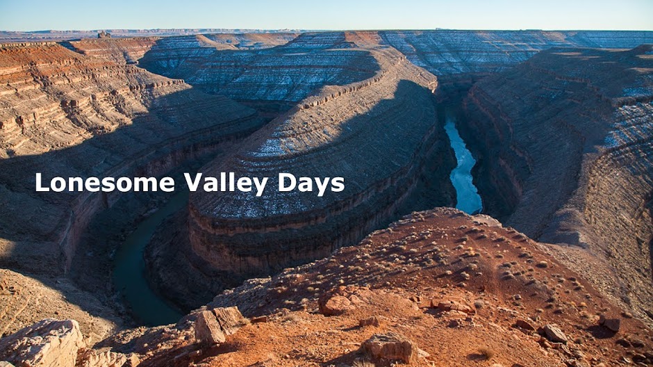
Across the southern edge of the Coconino Plateau. Meaning: the southern edge of the immense Colorado Plateau, too. Casual tourists who are not naturalists or geologists surely don't grasp the significance of driving off such an edge. It's not like you launch your car off into space. It's a highway, after all. Engineers designed the road to make it feasible to get down there from up here. 

Edge of the Colorado Plateau, south of Williams, Arizona.
 I only point this out so that the unaware appreciate it. Knowing about something makes it even more fun. That's my attitude.

So, down off the Colorado Plateau, into the beloved Central Arizona Highlands. That's their official name. My name for them is The In-Between Land. Because they're below the high country of Flagstaff, but still far above the hot desert of Phoenix. 

Prescott still lay a bit beneath where I was. The Perkinsville Road, so nice to be back alone in such familiar haunts. I had intended to continue on down, to take a motel room for the night. But when I saw Woodchute Mountain again in the evening light, I changed my mind. I had all I needed for the night: warm bedding, food, and...most of all...a superlative view. Turn off the ignition, I'm home for the night. Out in this high, wide, lonesome spectacle of nature that I know. 

Woodchute Mountain, from Perkinsville Road.
I'm home. Even though home is wherever I'm at. I'm a mountain man, I can't explain myself any better.

Tomorrow will find me back down in Prescott. All is well. 

Prints and photo products are available on my Fine Art America sales website:
http://stephen-krieg.pixels.com/


© Copyright 2014 Stephen J. Krieg

Friday, December 26, 2014

Return To Lonesome Valley, Part 1

Humphreys Peak and the San Francisco Peaks, from the Cones.
I'd been away. Up north, exploring some same old country anew. Which, surprisingly, took me a bit further north up onto the Colorado Plateau. 

I loved where I'd been the past decade. Not that it was easy, not by a long shot. But it was getting easier. More importantly, I was learning some important life lessons. That truism about an old dog can't learn new tricks: that applies to dogs. Sometimes we humans turn out to be smarter. 

Sometimes. But back to the trip at hand.

When one returns to a place as hallowed as Lonesome Valley, one should approach it just right. To barge right in from an Interstate highway at top speed wouldn't be right. Just try it yourself if you don't believe me.

So I preferred my way. Of course, I had the time. I'd made sure to have it, but even if I hadn't I would have figured out a way to pare the route down. Something.

Having driven across southeast Utah, sort of exiting the Canyon Country, across the San Juan River at Mexican Hat. Across the northwest reaches of the Navajo Nation. South on U.S. 89, wishing I could turn right and go back up to Marble Canyon and Lees Ferry. But one thing at a time. 

Approaching Flagstaff, northern Arizona. The small but lofty mountain range called the San Francisco Peaks growing ever closer. 

Then, still way north of Flagstaff, it was time to turn off the highway. A cattle guard with a bright orange newspaper mail box posted there. Across the high plain toward The Cones. The volcanic cinder cones at the very northern fringe of the San Francisco Volcanic Field. 

I love driving across that place. So wild and high and clear sky all around. So I indulged again.
SP Crater volcano, from the Cones on the Babbitt Ranches, north of Flagstaff, Arizona.
 The sexy "black" star of the area is listed on the maps as "SP Crater". It's a huge, massive black cone of cinders that erupted a short time ago, uh, geologically, but long enough to us that we can relax and appreciate it without feeling like we have to be ready to scramble for a high speed escape at any moment.

As always, I savored driving around the crater, and the adjacent ones, all older (wiser?) and doing their best to keep melding into the landscape, vegetation wise. Let that soil sprout more grasses and forbs. Trees, too, eventually. Just look a few miles south to the forested hills and mountains around Flagstaff. 
The Cones, some of them, from the high and still wild Babbitt Ranches land.
Then it was time to continue a few more miles west. Out to 180. But, this time, not south to Flagstaff again. Not yet. Instead, up to Valle, and down 64 to Williams. Then, only then, back down off the Mogollon Rim there. Off the southern edge of the entire Colorado Plateau, in fact.

Back down to Lonesome Valley. And I would pause on the way back down. It seemed only fitting, once I was there.

Stay Tuned.

Prints and photo products are available on my Fine Art America sales website:
http://stephen-krieg.pixels.com/


© 2014 Stephen J. Krieg

Friday, December 19, 2014

On The Bank Of The San Juan River

Mexican Hat Rock, the improbable geologic sombrero upside down.
December, Mexican Hat, extreme southern Utah. Snow swirling above, lightly. 

I feel a part of this country now, so I had no nervousness of driving higher. Up the Moki Dugway onto Cedar Mesa. A piece of cake. 

Still...why today? I had one more. Why not stay down on the San Juan for a night? I knew where to camp. Who wants to camp in December, way out here? 

I did. Had spent a night in a motel the night before. It's nice to have some creature comforts, shower up. But really it's kind of sterile. The window curtains pulled shut, the strange noises of the city. Or even others next door in a little far out motel town. 
The Goosenecks Of The San Juan River,  southeast Utah.
So I usually sleep better in the wilds. I follow my gut, my feelings. I've been right so far. Don't mess with success, right? And I was beneath Mexican Hat Rock, which somehow I had an affinity toward. Maybe a protection from. I didn't feel like I needed that, but comforting anyway.

Right. I chose a campsite out on the red sand, a flat spot with a fire ring. Just a short walk down the bank into the Tamarisk cover along the lip of the cold, muddy river. 

I was looking for firewood. Streams tend to provide that, in the form of driftwood. But in this case I wasn't rewarded. It was a fairly popular spot, after all. The easy wood already gone. 

I noticed the cardboard shell of a beer case. I like to clean up camps I visit. Even though most are so clean, they can use a little more. My theory is: love a place and it will take care of you, too. It's worked so far. Right?

I pulled the beer case out of the sand as I walked back to camp. I'd burn it in my campfire. 

And back at the fire ring, peering into the gulley as I relieved myself, I saw beer bottles. I jumped down the sand embankment to get them. I'd look like a garbage man with all this stuff in my truck. As if anybody would see it before I dropped it off somewhere proper. It felt right to me.

And I gathered what firewood I could. It would be a short fire, burning hot and quick. Good enough for some cheer. 

I had bought a new sleeping bag, and was curious to test it out. Here on the river bank, in December, it was cold but not like being up in the snow. Rather, just below it. Fine. I slept almost too warm, keeping most of the zipper open. 

Morning. Repack camp, shove off. 
Approaching Cedar Mesa, December snow, from Mexican Hat.
Since I was heading past the Goosenecks of the San Juan River, it was only proper to veer west a few miles and gawk over the edge again. The geologists call the Goosenecks far below to be "entrenched meanders". Indeed. 

This un-entrenched mountain man continued on. The Moki Dugway beckoned, up the foggy, snowy face of Cedar Mesa. 
Let's go, up the Moki Dugway. Bring it on.
 No problem. I knew this road now. Loved it. Photographic opportunities. Peace via ascent in my warm vehicle, stopping to get out for more images. 

Winter sunset, atop Cedar Mesa.
Then up onto Cedar Mesa. Former home of the Ancients. And future home, yet again? After all, they have come and gone. Who is to say they won't be back again? 

All is temporary.

Tuesday, December 9, 2014

Honoring The Ancient Ones, White Canyon

Ancestral Puebloan cliff dwelling ruin, White Canyon.
I followed the trail down from the rim once again. Switchbacking down the slickrock sandstone (which isn't slippery, even when wet). Down steps both built and cut, down some metal stairs. Down three wooden ladders bolted to the cliff. 

Then, down in the canyon bottom, the stream bed, there is no maintained trail. Doesn't need to be: the 500 foot tall canyon walls provide all the side rails you could want. 

I walked upstream, enjoying the solitude. Early December in a remote part of remote San Juan County, Utah. Colorado Plateau, canyon country. The stream was trickling between pools. Cold sandstone wall on the left side. Ice covering some of the pools, even. The last of fall's leaves frozen on top, slowly melting through, because they are darker than the white-blue ice and so absorb more of the day's warmth. Interesting to ponder a dead leaf being warmer than the ice around it.

I came to a wide bend in the little canyon. Looking up on the left hand cliff, I saw ruins. No real surprise. A south facing alcove of sandstone to catch all the low winter sun possible.

Cliff dwelling pueblo ruins. Probably a single family, a few rooms. According to the best archaeological information, they left about 800 years ago. And haven't come back. At least not to live there again. Their descendants may have visited. Probably did. They won't say. 

Just like I won't say exactly where this is located. Because if you really want to know you will do the work to find out. Hopefully that will also make you respectful enough to be guarded about who you share it with, too. 

When you respect a place, you love it. When you care for it, it cares back. It will probably even take care of you. 

Remember that.
T-shaped doorway, Ancestral Puebloan ruin, White Canyon.
Prints and photo products are available on my Fine Art America sales website:
http://stephen-krieg.pixels.com/


© Copyright 2014 Stephen J. Krieg