Wednesday, December 21, 2016

December Trout Fishing

At Waldens Lake for some more December trout fishing.
"I would rather sit on a pumpkin and have it all to myself, than be crowded on a velvet cushion." -- Henry David Thoreau.

Yes, Henry. I hear you. I continued to fish for trout at the lake (which I have nicknamed Waldens Lake) from the delightful fall into the early winter. On only a few days was there another fisherman on the lake. I had it all to myself almost all the time.

Last catch of Rainbow Trout from Waldens Lake.

I was there almost every day, often twice a day so that I could be there for sunrise and sunset colors when they occurred.

My freezer has plenty of trout to tide me over the winter.

Shortly before the deep freeze weather finally arrived on December 18, I made a short video to wrap up the season. I've embedded it below, from my YouTube channel at YouTube.com/stephenkrieg.


© Copyright 2016 Stephen J. Krieg


Monday, October 24, 2016

View From Abajo Peak

Looking down to Monticello from Abajo Peak.
Southeast Utah in October. What a place to be in. The Four Corners country, the mile high (and above) Colorado Plateau.

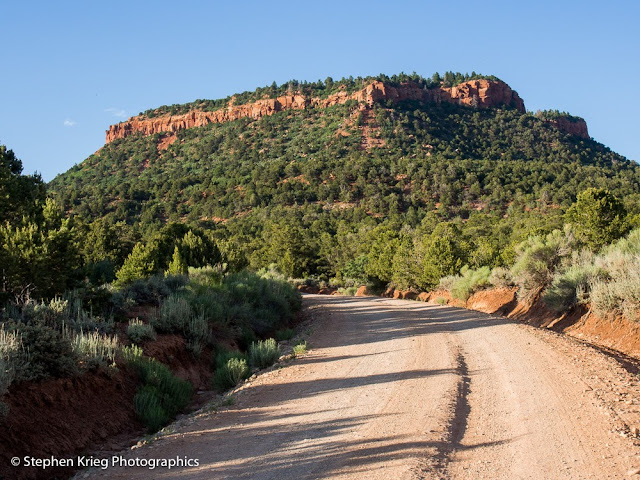
At the edge of Monticello, Utah, I caught my limit of trout, then drove up the public road to Abajo Peak. It's the forefront, the frontispiece, of the Abajo Mountains. Also called the Blue Mountains by the locals.

Geologically, they are a laccolith. Molten rock (magma) had surged upward but not exploded onto the surface like those photos and videos we see from Hawaii. Later (much later, though in geologic terms quite recent) the overlying layers of rock eroded away. Exposing the long hardened granite that had swelled up.

And there you have it, in as simple of terms as I understand.

You don't even have to care about such scientific things to appreciate what has happened since. What's there now. Forests draping those mountains and foothills. A rural, small town culture surrounding them. Clean air, clean water.

It doesn't get much better than this. Probably not any better.

The road up Abajo Peak, late September.

Photo location: Monticello, San Juan County, Utah.

Prints and photo products are available on my Fine Art America sales website:
http://stephen-krieg.pixels.com/


© Copyright 2016 Stephen J. Krieg

Wednesday, September 21, 2016

Cave Towers and Harvest Moon, Southeast Utah

Apex of the evening: Harvest Moon over White Mesa, from Cedar Mesa.
It was the evening of the September Full Moon. The Harvest Moon, named back in pre-industrial days when the corn had to be cut and tied into shocks to finish drying, and the bright moon rising at dusk allowed the families to work the fields as late as they could stand it. Because it was their year's crop, their income, their everything, on winter's doorstep.

But this was 2016, not 1700s colonial America back East. The moon didn't care. It would rise true in its orbit regardless of who cared.

I cared. I watch for Full Moon time each month. For landscape photos. For the once in a month visual and visceral experience. Weather permitting, you know, so some months are clouded out even here in the high and dry and lovely mostly clear skies of the desert Southwest.
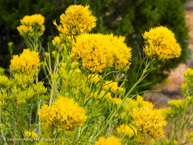
Rabbitbrush in bloom, September, San Juan County, Utah.
This time I was scheming for a different kind of photograph. One featuring the rubble of an ancient tower ruin on Cedar Mesa in southeast Utah. If I could line it up with the rising moon at dusk, that could be so cool. There was only one way to find out.

So I drove out to a ruin that is known locally and in certain guide books as Cave Towers Ruin. It's on public land, but it's unmarked from the highway, so you have to know how to get there. Open the gate, close the gate behind you, and drive on in. Unless you have a high clearance vehicle (AWD, like a Subaru) you should stop at the new (courtesy of Friends Of Cedar Mesa) buck-and-pole wooden fence and walk the rest of the way. It's not far.

West tower ruin at Cave Towers.
Cave Towers? What kind of name is that? Isn't that an oxymoron? Is it in a cave, or is it towering above the landscape? It can't be both, can it?

Well, why not? Towers above the cave? A recess (overhanging) cave in the sandstone layers, with cliff dwellings below and brazen towers above on the canyon rim. Not a subterranean cavern.

Late day sunlight just below the rim on cliff dwellings rubble.
Now it's making more sense. For the Ancestral Puebloans of 800 years ago, a reliable water source was a strategic scarcity to be defended for the livelihood of the community. Building a two story tower out of shaped sandstone slabs and adobe mortar announced to anybody approaching that "we live here, respect us or suffer the consequences". It is also suspected that such towers were used to build signal fires. A communication network across vast distances. Fire light, after all, is speed of light messaging. All is well. Or: enemies approaching, spread the alarm.

Cliff dwellings below the rim, underneath the towers. How to get down there?
Don't ask how I got off on all of that. Obviously there was a lot more on my mind as I walked in to the rubble of the several towers that were in this one spot. This lip of a side canyon of Mule Canyon, with its spring below. Even an historic gravesite fenced off with a small slab of sandstone for a tombstone. (Things are always surprising in Canyon Country).

Peering into the canyon below Cave Towers Ruin. Sleeping Ute Mountain on the far horizon.
 Yes, I was thinking of the Ancient Ones as I again visited this sacred spot. The mid-September sun was already low, sliding quickly toward sunset. I arrived at my favorite tower ruin, the most prominent one, and got out my compass. Using The Photographer's Ephemeris app, I knew that the full moon would rise almost due East. It was already swinging back north from its southeasterly position at midsummer. 
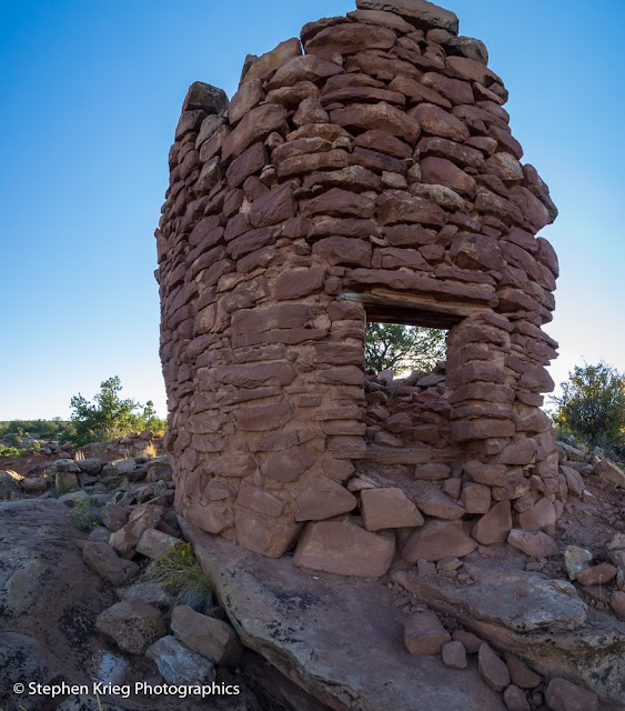
The west tower and its entry doorway, from below.
I worked around the site, but it soon become obvious that I could not get the moonrise in a good composition with the tower ruin this time. Maybe October. So I photographed the tower rubble and its environs and quickly walked back out to the truck. There might still be time to find a better location for moonrise, without any ruins. Though on the walk out I could not help but to photograph a lovely clump of bright yellow wildflowers.
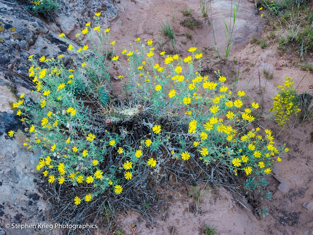
Yellow wildflowers, some of the last of the season.
Climbing back westward up Highway 95, I decided to make my last stand (of the evening) at Salvation Point, elevation 7,110 feet. A wide open clear view to the east.

The Earth's Shadow, and Sleeping Ute Mountain, just after sunset, from Salvation Point.
 The sun set behind me as I continued to stare east. The Earth's shadow grew blue, with the pink Venus Belt fringing it at the top. Sleeping Ute Mountain lay stretched out, a lumpy and slightly darker blue across the state line in Colorado.

Waiting, waiting. Waiting for the moon to show. I knew it would be about 20 minutes after sunset this night.

Harvest Moon emergence, from Cedar Mesa.
Then it began to peek through the blue.  The upper yellow arc of the circle still hidden behind some clouds, or maybe even the La Plata mountain range in southwest Colorado. The haze on the horizon made it a deep yellow-orange orb slowly rising from the blue. Incredibly lovely. Almost orange as a pumpkin, fitting for the Harvest Moon in America.

Lord of the eastern horizon on this lovely September evening...
 Silently creeping up as the Earth rotated beneath my feet toward it.

A lonely highway in the middle of nowhere, so almost no traffic. Wide open skies. Moonrise. The high desert. September, the second best month of the year.

Panorama: Risen moon over White Mesa, from Cedar Mesa, Utah.

It doesn't get much better than this.

Photo location: San Juan County, southeast Utah.

Prints and photo products are available on my Fine Art America sales website:
http://stephen-krieg.pixels.com/


© Copyright 2016 Stephen J. Krieg


Thursday, July 28, 2016

Natural Bridges Monsoon Waterfalls

Monsoon thundershower waterfalls into White Canyon, near Sipapu Natural Bridge.
Visitors to the Colorado Plateau--especially to canyon country--are often surprised at our late summer "monsoon" thunderstorm season. When we usually get half of our annual precipitation. The other half being wintertime snow.

Rain coming down by the buckets! It won't last long.
Lately I got to watch another such event. In the late morning, cumulus clouds were building to the north over the mountains. They soon turned into towering thunderheads, the result of moisture from the south (Baja California) colliding with our hot dry summer blue skies.

A waterfall in two parts!
I drove Bridge View Drive to get a look down into White Canyon during the storm. On the east side of the park it was pouring so hard I didn't dare get out to photograph. Instead I lowered the passenger side window and shot right from the cab of the truck.

A heavy rain in the high desert starts running off fast. Especially when large portions of the watershed are bare sandstone slickrock. It's going to go downhill of course, and channeled into grooves and washes in the rock. To pour off of any cliff that's in the way.

Zooming in on one canyon rim waterfall, I was surprised to see that it had two parts to it. The surface tension of the rock made some of it run down the cliff face. But when the force of the water became too much, the rest was vaulted off into space from the very rim. I'd never seen--or at least noticed--that before.

Rain, rain, rain. Down the canyon walls of Cedar Mesa Sandstone.
I then drove the rest of the loop road through the park. Typical of desert thunderstorms, it was raining locally--very locally. The west side of the park, only about five miles away as the raven flies--was receiving almost no rain.

So I drove around the loop a second time (it's one way) to see what was going on in the rainy side of the park.

Notice the difference in turbidity (how muddy different flows are).

It had backed off some. Enough that I could get out and photograph instead of staying huddled in my vehicle and shooting through the downpouring curtain of water.

It was interesting to see how clear some of the waterfalls were, and how muddy others were. It all depends on what part of the site it's draining: bare rock, or soil.

Visitors taking in the temporary spectacle. Almost an inch of rain fell in about an hour.

 Photo location: Natural Bridges National Monument, southeast Utah.

© Copyright Stephen J. Krieg


Tuesday, July 26, 2016

Send In The Clouds: Cedar Mesa

Monsoon season thunderhead, Cedar Mesa.
The monsoon season's thunderhead clouds had been building all afternoon in southeast Utah's San Juan County (the largest and least populated county in Utah). I was driving east to Blanding to buy groceries.

I had been driving down Cedar Mesa, then over Comb Ridge, past the Cheese And Raisins Hills, lost in thought. Relaxed. Trying to remember if I'd seen a good brand of coffee on the shelves of the little grocery store in Blanding.

I glanced to my left, and the brilliance of the massive elongated thunderhead cloud in the early evening light snapped me out of my lame thoughts. Massively pulling over to the weed choked shoulder of Highway 95 (no traffic to worry about out here) I jumped out, camera in hand. The blues, the grays, the whites; the sunbeams radiating outward above.

No wonder I live here.

So, back toward Blanding. Nice small town. Squeaky clean Mormon town. "The Gateway To Adventure", the welcoming billboard proclaims. Mountains nearby, canyons, too. Clean air and water. Canyon country.

Hwy. 95 intersects with US 191 a few miles south of town. So what? So more opportunity to view the surrounding skies. And on this evening it was teasing me further still.

A prime southeast Utah thunderhead downpour, from Blanding.
I had to turn left onto the street that led to the athletic fields. Because I knew there was a clear view to the west from there, toward distant Cedar Mesa from where I'd just come, the Bears Ears buttes, and--these few minutes only--yet another thunderstorm cloud, rain pouring straight down to make it look like a heavenly version of a nuclear bomb mushroom cloud. Heaven raining on Earth, and on the high desert, to boot. The way it should be.

I didn't linger long in the grocery store. Though it was payday and my larder back home was looking pitifully meager.

Because I wanted to head back home, back toward the sunset and whatever those brilliant blue, white and black monster clouds might bring at sunset.

Sunset thunderhead, Cedar Mesa.
After slipping back down through the red rock cut in Comb Ridge and starting the climb back up onto Cedar Mesa, I had what I'd been hoping for. Lightning flashing to the south. I pulled over and got out to photograph. On this lonely stretch of highway, not a single vehicle passed by as I savored the clouds glowing with sunset on the west side, and blue-black shadow on the east.


Photo location: San Juan County, southeast Utah.

© Copyright 2016 Stephen J. Krieg

Saturday, July 2, 2016

Bears Ears

A summer evening stop between the Ears.
Up the dirt road to Bears Ears. To those iconic buttes (flat topped mountains) that are the focus of some political discussion these days. Things change, after all.

So let's go. Let's get out of this high desert summer heat. Up in elevation, and it won't take long. Not around here.

Crossing the National Forest boundary.
There's road dust behind me, even though I'm going slowly. It's been hot and dry around these parts lately. I slow down even more as I approach some folks going the other way. They wave and say "How are you doing?"

The East Ear, in summer afternoon light.
I pass between the Ears. Visitors, when viewing them from below, are startled to find out there is a road that goes right between them.

The shade of a Pinyon pine tree below the Bears Ears.
On the north side of the Ears, I once again do my best to savor the high mountain meadow scenery.

East Bears Ears Butte, from Elk Ridge.
The lupine were blooming in the high meadow. As usual I couldn't help but stop to admire.


But there were too many cows there, grazing on the public forage. So I Drove on.

Mule deer buck in velvet, Elk Ridge.
The deer were quite relaxed, mostly. They can feel when it's legal hunting season. Which it was not then.

Sunrise colors from camp.
I decided upon a campsite and settled in. Serenity in the forest.

 Photo location: San Juan County, southeast Utah.

© Copyright 2016 Stephen J. Krieg


Saving A Snake

Gopher snake, Natural Bridges highway.
June, and it's hot already, even at 6,500 feet. It's time to go higher. Up into the cooler mountains. Elk Ridge, beyond the Bears Ears Buttes.

But while driving out the Natural Bridges entrance road I suddenly swerved to the right. A fairly big snake was stretched across the centerline. Not a safe place to be.

I just missed driving over it myself. I pulled over to the side of the road, hoping I didn't hit even its tail. It hadn't been moving, and I was afraid it's been run over already, spine broken.

Walking up to it, (making sure it wasn't a rattlesnake), it looked fine. Nobody had run over it. Yet. It was a hot afternoon, but it seemed to be enjoying the heat of the pavement. What, is it not hot enough for you on the dirt to either side of the road?

Move, darn you. I went to its tail end and tried to look menacing. It worked, the snake started to move away. I crowded it some more. It slithered onto the dirt shoulder of the road.

My work there was done. I got back into my car, and within a few moments another car passed going the other way. The one that would likely have done my snake friend in.

Now it was time to drive up into the cool mountain forests.

Photo location: Natural Bridges National Monument, southeast Utah.

© Copyright 2016 Stephen J. Krieg

Friday, May 6, 2016

Down North Wash From Hanksville, Utah

The Silver Eagle convenience store in Hanksville, Utah. Effectively, the heart of the town. The Henry Mountains in the distance. A high desert outpost with...heart.
I must say that I love Hanksville in southeast Utah. But then again I love most lonesome towns. Notwithstanding the opportunity to stock up on gasoline and food, I like the people. In my travels I have noticed that the citizens of rural areas are the most relaxed, friendly, and helpful there are. 

The Henry Mountains, from Highway 95 south of Hanksville.


I believe it has to do with their environment. When you live far from anywhere, you realize how closely you might be to the edge, if you hit a tough spot. In short, people out there tend to look out for each other. And they look out for anyone else that might need a hand, too. Which is why I keep finding myself gravitating to rural places.

Well, except for the beauty of such locations. They go hand in hand, naturally.
Sand dunes turned to rock and uplifted a mile above sea level. After millions of years, I mean.


I passed back through Hanksville recently. There isn't much to the town, really. And many services are closed during the winter offseason. This is a summertime tourist town. Spring, summer, early fall. Outside of that the locals settle back into whatever routine they like to do.

Cottonwood trees with spring growth, North Wash.
Last year I stopped by the single grocery store. Its shelves were sparsely stocked, in keeping with the winter season. Keep inventory low, you know. The elderly cashier at the front said: "I love this place. I wouldn't live anywhere else!" 

At first a new visitor might look around the dusty town and wonder if she was nuts. No Walmart or a major chain grocery store. No national chain motel. Though I can enthusiastically recommend the Whispering Sands motel, right next to the Silver Eagle. The accommodations are splendid, especially for such an out of the way respite. 


Shadow of the Highway 95 bridge onto the Colorado River at Hite Crossing.

However, despite wanting yet again to buy a place there and settle down, I turned my truck east again, out of Hanksville. Not that I won't return soon.

Down Highway 95. The Henry Mountains glowing down at me, with their coat of snow. The high desert below. 

Photo location: southeast Utah.

© Copyright 2016 Stephen J. Krieg


Sunday, February 14, 2016

San Juan River Goosenecks, Winter


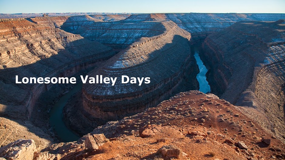
San Juan River, Utah, winter, from Goosenecks State Park.

An extra snowy winter in the high desert canyon country of southeast Utah. In other words, perfect for this time of year. In the desert one always dreams of rain, even while appreciating the lack of it. Cycles and seasons.

Goosenecks of the San Juan River, Utah.
 Another visit down to Goosenecks State Park, overlooking the incredible sinuous canyon depths there. The muddy river flowing on around the bends it continues to scour ever deeper. Ice floes gently scraping the rocks along the river banks. 

San Juan River and sky reflection, winter.
 The snow reveals: in winter, north facing slopes get no sunlight. Their shade allows the snow to remain, for a while at least. On the south facing slopes the snow is quickly melted. Polar opposites, in balance. 

The stark beauty of the high desert canyon landscape. In winter.

Photo location: Goosenecks State Park, San Juan County, Utah.

© Copyright 2016 Stephen J. Krieg